The Short Version
- Esri is integrating AI into its geographic information systems technology, making location data and mapping tools more accessible to real estate professionals without specialized GIS expertise.
- Users now can talk to AI assistants in natural language within tools designed to identify similar markets, analyze trade areas and streamline site selection.
- TSCG’s new Broker Intelligence platform combines AI with proprietary data and that of Esri and others to simplify market analysis, site selection and broker workflows. It launches internally in November, followed by a public version for brokerage firms, retailers and other subscribers.
- Ripco Real Estate is connecting Anthropic’s Claude to Esri’s mapping and analytics tools, aiming to give its brokers faster, more direct access to demographic reports, location data and other GIS capabilities.
- Brokers’ local market knowledge, relationships and on-the-ground assessments remain essential, despite advances in AI-assisted analysis, to evaluating sites and closing deals.
Esri Is Using AI to Simplify GIS Analysis and Put More Location Data at Users’ Fingertips
Analysts have long used Esri’s geographic information systems software to map the variables that matter most to brokers, retailers and developers. Now the company is weaving AI into its maps, dashboards and visual tools so people without GIS expertise can do more of that work themselves, said director of business industry solutions Gregg Katz.
That includes having AI assistants do things like run location-based demographic reports, conduct cannibalization studies, chart residential developments and generally provide a clearer picture of, as Esri puts it, “where things are” and “what things are like there.”
“The way we’re looking at AI, it’s more about how to gain efficiencies and help with the process, and the most exciting piece is how it can help translate things for a non-geospatially educated person,” Katz said. “You can ask a business question and then have AI start talking back to you. Most importantly, it’s in the language of business and through the lens of a map, which is the best storytelling vehicle in retail and real estate.”
Esri advances from the past six months include:
AI-powered location intelligence assistants: New AI assistants make it possible to run natural-language queries within Esri’s ArcGIS location intelligence and mapping platform, including ArcGIS Business Analyst for site selection and trade area analysis.
AI-generated ‘embeddings’: Esri now can compress more than 5,000 demographic, socioeconomic, housing and environmental variables into compact representations of place, allowing users to identify markets, neighborhoods and trade areas that are statistically similar to other high-performing locations.
Agentic AI and MCP integration: Esri now supports the Model Context Protocol, an open standard that connects AI applications to external tools and data sources, including a company’s own vetted information. That means users can run AI-assisted queries within authoritative GIS datasets and systems, as opposed to asking an LLM to scour the internet. “You can ask complex business questions and have confidence in the data and its outputs,” Katz said.
Geospatial foundation models: Esri is expanding its library of geospatial foundation models — i.e., AI models trained on geographic data that can perform a range of geospatial tasks. One example is the Esri-developed Global Location Encoder, a deep learning model that converts geographic coordinates into data describing the characteristics of a place. These advances make it possible to run analyses related to market intelligence, land use, development monitoring, forecasting and imagery without needing to build AI models of your own, Katz said.
Plain-language questions that speed up GIS queries: Esri continues to find ways to connect previously isolated data about properties, tenants, consumers and markets, Katz said. The goal is to help users like brokers, leasing agents, developers, executives and researchers better understand the complex relationships that influence demand, investment performance and location strategy. Previously, he explained, answering a site-selection question like “Where should we open our next five locations?” required familiarity with GIS analysis and geoprocessing tools. “Someone had to find and prep the datasets — things like demographics, foot traffic, competitor locations and drive times — choose and sequence the geoprocessing tools, run them and build a map,” Katz said. “For a broker or retailer, that meant a request to a specialist, waiting for a few days or weeks and a static result.” Non-experts now can ask such questions in plain language, and a geospatial AI agent will identify the relevant data, run the analysis and respond with an explanation and a map. “The user can follow up immediately by saying ‘Now show me only sites near a grocery anchor,’” Katz said.
And Esri and its existing partners continue put more GIS data at users’ fingertips. One example is the aggregated and standardized land parcel data provided by Regrid, which draws from thousands of local government sources across the U.S. With access to these datasets, a broker looking to help a grocer open a 55,000-square-foot store in the Atlanta suburbs, for example, could use Esri to find parcels larger than 10 acres, filter for commercial zoning, exclude flood-risk areas and overlay household income, population growth and drive-time access.
TSCG Builds AI-Powered Broker Platform Using Esri and Other Data Sources
TSCG is integrating Esri’s latest advances into a proprietary platform that will be called Broker Intelligence, said TSCG partner, managing director and executive vice president of technology and analytics Bryan Chandler. A version built for internal TSCG users will go live in November, and a version for external subscribers like retailers and brokerage firms will launch in early 2027.
It’s all part of a larger ecosystem of tools and apps that TSCG is building to automate work like zoning and permitting research, lease abstraction, site searches and reporting, based on both internal and third-party data and technology.
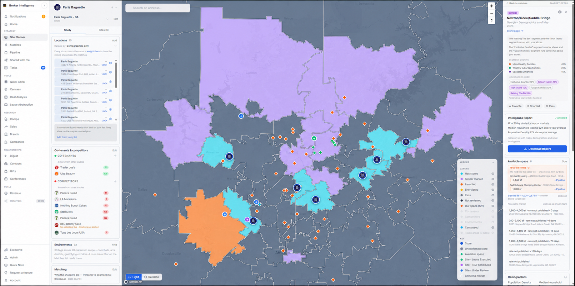
The site planner in TSCG’s AI-assisted Broker Intelligence platform identifies markets that are broadly similar to those of brands’ existing locations, drawing on more than 60 demographic measures provided by Esri. Teal indicates an activated market, while purple indicates a similar demographic fit. Orange shows markets users have favorited. Image courtesy of TSCG
Chandler — who leads a TSCG team of 20 GIS analysts, data engineers, IT professionals, researchers and other specialists — pointed to TSCG clients’ hunger for information. “The retailers we support are definitely asking for more information,” he said. “Population and traffic counts, median household income, housing starts — the list of the data they want from our brokers seems to get longer each year.” That has translated into more work for TSCG brokers and the in-house GIS, analytics and marketing teams who handle their requests. “There are a number of listings websites that [brokers] are looking through, all sorts of due diligence and lease abstractions, and they are pulling demographics and working to understand the consumer,” Chandler said. “Right now, that’s a pretty manual process. You have to send emails and log tickets.”
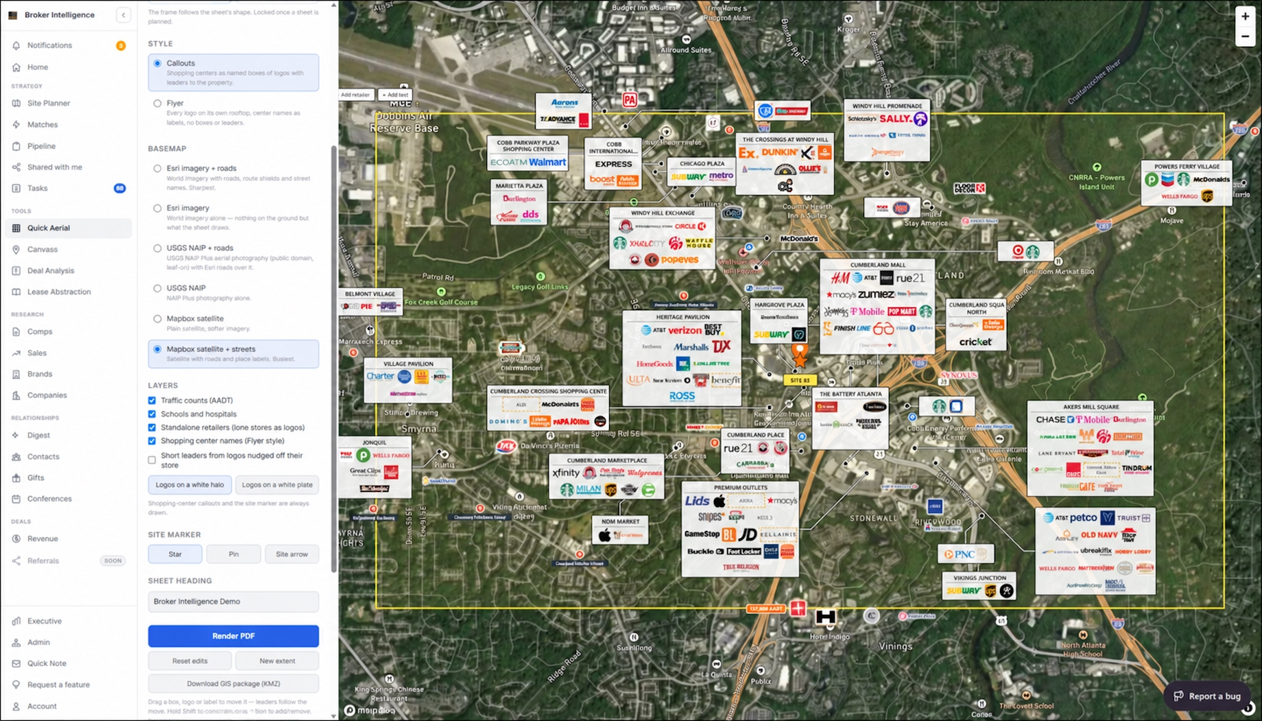
One feature within TSCG’s Broker Intelligence platform pulls together Esri and other resources so that brokers, retailers and marketing teams can generate their own aerials in as little as five minutes. Image courtesy of TSCG
Broker Intelligence combines AI with the expertise of human analysts to help users manage workflows, build market aerials and analyze markets, trade areas and brands, Chandler said. TSCG’s use of APIs allows different programs from within the company’s tech stack to share data within the platform, eliminating the need to remember multiple logins and passwords. The web-based, mobile-accessible platform runs deep dives into tenant-expansion histories, site criteria and future real estate plans, constantly looking for matching spaces. “All of these AI subagents just start churning away and filling in all these data points,” Chandler said. “It has grown to be a very comprehensive platform that is ideally going to make analysis and site selection a lot easier. It’s about moving from reactive to proactive.”
Ripco Connects Claude to Esri Data To Simplify GIS Analysis
Ripco Real Estate GIS director and analyst Andie Miller leads a five-person GIS team that, in tandem with the data operations department led by vice president Will Parra, is integrating Anthropic’s Claude with Esri’s mapping and analytics capabilities via MCP.
Miller explained that her team is building MCP tools that follow the established methods of Ripco’s analysts. That means brokers can use Claude to pull many of the same reports on demographics, void analysis and more that in-house experts traditionally prepared for them. Foundational reports should be AI-enabled by the end of the year, Miller said, and more complex capabilities will come in later phases.
The goal is for more than 200 Ripco professionals to get information faster and take greater advantage of datasets from both Esri and other third parties. A broker could, for example, go into Claude and ask to see all Trader Joe’s stores on Long Island, along with standard demographic reports showing the 1-, 3- and 5-mile radius for each location. This prompt then would pull the Trader Joe’s locations using a database from third-party provider ChainXY, Miller explained. The system automatically would geocode the site and store addresses, draw the radius rings and then enrich these areas with data from Esri’s demographics suite. The user then could ask Claude to compare the demos of existing Trader Joe’s stores to potential sites in target markets.
The project will put the thousands of variables that Esri offers, along with all kinds of third-party data available to Ripco analysts, at Ripco brokers’ fingertips. The list includes residential and commercial developments, government land parcels, building owners, population density, cannibalization trends and co-tenancy. “It can be as complex as working through millions of records,” Miller said.
But while AI-assisted automation can accelerate analysis and site selection, human expertise still matters, Miller said. For starters, some maps and reports depend on higher-level GIS and data science skills. And Ripco brokers continue to crisscross markets by car, visit sites on foot and weigh factors like the quality of the spaces or the ease of ingress and egress at the centers.
Once the system identifies promising search areas for a tenant, the local broker still will need their market knowledge and relationships with local landlords to find the best site and close the deal, Miller said. “AI is a bridge to democratize GIS data for our brokers. Real estate agents think spatially — location, location, location — they see spatially, they’re on the streets. AI is giving them the tools they need to actually get the data they want in the way they’re used to working.”
By Joel Groover
Contributor, Commerce + Communities Today